A leap forward in flood risk management

Through a 10-year investment programme, grounded in evidence and detailed analysis, Ireland has moved beyond reactive flood protection to a holistic approach to flood risk management. Mark Adamson, Catchment Flood Risk Assessment and Management (CFRAM) Programme Director, OPW explains.
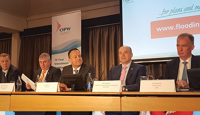
In Athlone, on 3 May, Minster of State with responsibility for the Office of Public Works (OPW) and Flood Relief, Kevin ‘Boxer’ Moran, TD, in the presence of An Taoiseach, Leo Varadkar, TD, and the Minister for Communications, Climate Action and Environment, Denis Naughten, TD, launched the 29 Flood Risk Management Plans for Ireland. The Plans set out a 10-year, €1 billion programme of capital investment in new flood risk management measures, including 118 new flood relief schemes, of which 50 will be advanced in the initial phase to detailed design and construction with investment of more than €250 million.
The new schemes proposed in the Plans build on significant investment in flood defence schemes since 1995, which has facilitated the delivery of 42 major flood relief schemes around the country. These schemes successfully provide protection to 9,500 properties and the economic benefit to the State in damage and losses avoided is estimated at €1.9 billion. There are also nine major flood relief schemes currently under construction and a further 24 at design or planning stage.
The Flood Risk Management Plans, along with detailed flood maps for the 300 communities that informed their preparation, developed through the National CFRAM Programme have been published on the new OPW map and plan viewer website: www.floodinfo.ie. The website allows users to see at a glance what measures are in place and proposed for locations throughout the country and provide a detailed picture of flood risk for existing and potential future flood event scenarios.
The origins of the CFRAM Programme were in the Report of the Flood Policy Review Group that was approved by government. The adopted policy included a pro-active, catchment-based and holistic approach to flood risk management, developing a sound information base along with a greater non-structural flood risk management capacity to complement the ongoing work in flood protection. The Report also included specific recommendations for the implementation of a flood mapping programme and the development of flood risk management plans that lead to the OPW developing the CFRAM Programme. The CFRAM Programme also delivers on key requirements of the EU ‘Floods’ Directive that came into force in 2007.
Pilot CFRAM studies were undertaken in the Lee Catchment in Cork, the Dodder Catchment in Dublin and for the Fingal-East Meath Area to develop and test this new method of working. With the pilot studies substantially completed in 2010-2011, the National CFRAM Programme was initiated, focusing on 300 communities where the flood risk was considered to be most significant, which were identified through a national screening assessment for flood risk (the Preliminary Flood Risk Assessment, or PFRA) undertaken between 2009 and 2011. The National CFRAM Programme has involved:
• the survey of 6,500km of river channel and structures in, over or alongside the channels;
• the development of a suite of state-of-the-art computational hydraulic models for these rivers and their floodplains, and of the coastal floodplains for 90 communities;
• the preparation of a range of flood maps for the 300 communities, for up to eight flood event magnitudes (from frequent, minor floods up to very extreme events) for the current conditions, and also for two potential future scenarios that take into account the potential impacts of climate change;
• the assessment of options for managing the risk to these communities, including development to outline design, costing, economic and environmental appraisal and assessment under a multi-criteria analysis to determine the benefits and impacts of different options across a wide range of social, economic, environmental, cultural and technical objectives; and
• nearly 500 public consultation days held in the relevant communities to engage with stakeholders and local people on the flood maps and the options for managing flood risk;
The CFRAM Programme has been the largest programme of flood risk assessment and management ever undertaken in the State. Approximately 40,000 different flood maps have been produced to identify the flood risk for communities in which about three million people live; nearly two-thirds of the national population. These maps:
• support the National Development Plan, the National Planning Framework and the National Adaptation Framework by providing the essential flood risk information to inform investment, development and adaptation planning;
• inform sustainable planning and development management to avoid or minimise the creation of new flood risks that could otherwise arise through inappropriate future development;
• raise awareness of flood risk; providing a platform for individual and community resilience; and
• inform emergency response planning for future flood events.
“The CFRAM Programme has been the largest programme of flood risk assessment and management ever undertaken in the State. Approximately 40,000 different flood maps have been produced.”
The flood relief schemes identified through the CFRAM Programme will protect 18,000 properties. Indeed, schemes to protect 6,500 properties are already underway and are at design, planning or construction stage, having been identified through the pilot studies or accelerated under the National Programme. These schemes, together with those already completed or in construction, planning or design, will protect 33,000 properties; about 80 per cent of those estimated as being at risk nationally from rivers and the sea.
The Plans also set out a range of measures to protect or reduce the likely impact of flood events for all areas, including properties outside of the communities assessed under the CFRAM Programme. Such measures include:
• ongoing maintenance by the OPW of Arterial Drainage Schemes that provide drainage for 650,000 acres of agricultural land;
• the ‘Minor Works’ Scheme, through which the OPW will continue to provide funding to local authorities to implement local solutions to local problems, building on the 500 projects already completed under the Scheme that provide benefit to 6,500 properties; and
• the establishment of the National Flood Forecasting and Warning Service by Met Éireann, in conjunction with the OPW, which is already well underway.
The launch of the Plans represents the culmination of years of analysis to support the proposals for protection measures set out in the Plans and to advance non-structural programmes to support flood risk prevention, preparedness and resilience. An Taoiseach stated that the Plans “are a testament to how this Government takes informed decisions on investment for major capital projects, by targeting investment against a strong evidence base”.
Minister ‘Boxer’ Moran said: “We are seeing major progress being achieved and, in partnership with our local authority colleagues, we will continue with our endeavours to progress flood risk management schemes nationally over the next 10 years of this significant flood risk management investment programme.”
The challenging capital programme involves doubling the annual budget by 2021, with 50 new schemes to be initiated alongside the 33 already in hand, and more work is still to be done in enhancing our non-structural flood risk management capacity. The second cycle of implementation of the ‘Floods’ Directive will involve enhancing and refining the work to date, including assessment of flood risk in rural areas outside of the communities assessed to date to further enhance our understanding of flood risk nationally.
An evolutionary step forward has been taken in flood risk management in Ireland. We have moved on from a reliance on flood protection reacting to previous incidents, to a holistic approach to flood risk management, with, for the first time, a 10-year evidence-based investment programme for flood relief, informed by a comprehensive understanding of flood risk built on detailed analysis.
For more information:T: 046 942 6999
E: floodinfo@opw.ie
W: www.floodinfo.ie, www.opw.ie