High performance computing accelerating Earth observation and inland water quality research
Remote sensing about objects and areas from satellites enables the collection of numerous forms of extremely valuable information such as vegetation type and coverage, quality of inland and coastal waters, land use type, urban infrastructure growth, location of geothermal resources etc. and is fast becoming one of the most important technologies of the 21st Century.
The ability to exploit this technology has been recognised by government agencies, researchers and private companies. However the extraction of this high volume of information poses a major computational challenge and high performance computing (HPC) infrastructure is required to provide the crucial architectural element for information extraction.
Advances in sensor and computer technology has revolutionised the way remote sensing data is collected, managed and analysed. The incorporation of latest-generation sensors such as Synthetic Aperture Radar (SAR) sensor on board Sentinel-1, capable of acquiring weather independent imagery to detect vertical movement on the ground, and Multispectral Instrument (MSI) on board Sentinel-2, capable of collecting information about the health of vegetation, is producing a nearly continual stream of high-dimensional data.
This explosion in the amount of collected information has rapidly created new processing challenges, necessitating the development of computationally efficient techniques. These techniques transform the massive amounts of remote sensing data into a scientific understanding which is critical for Earth science. Examples of these include:
- how has the coastal shoreline eroded in the last decade; and
- how the changes in land use practices have been affecting the quality of inland waters.
As the world-wide community of organisations utilising remote sensing data continually grows, an efficient mechanism to share this data as well as providing the required resources for information extraction has arisen. To meet this requirement the Irish Centre for High-End Computing (ICHEC) hosts and maintains the Irish national collaborative ground segment for European Space Agency (ESA) as part of their Copernicus program, as well as providing organisations with the necessary expertise to exploit these vast data sources.
The data archive consists of:
- Sentinel-1 (To observe earth using radar beams);
- Sentinel-2 (Optical mission observing both land and water);
- Sentinel-3 (Oceanic mission) collecting information on our oceans; and
- Sentinel-5P (To study atmospheric gases).
It is estimated that in 2017 Earth Observation commercial data sales were between €3.7 and €4.5 Billion providing an enormous market opportunity for the future and is considered a key element in the European Research Road Map for the next decade.
INFER
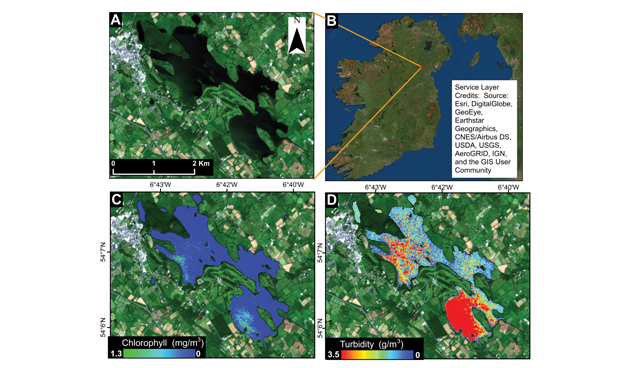
ICHEC are partnering with Dundalk Institute of Technology (DkIT), to undertake a detailed and comprehensive 3-year study (INFER) funded by the EPA to assess the quality of inland waters in Ireland using remote sensing. The INFER project utilises the data acquired from Sentinel-2 constellation from two satellites (Sentinel 2A and 2B) to provide an image of the earth at 290 km wide swaths with the revisit time of 5 days. Sentinel-2 is a multispectral optical mission designed for land, water and coastal application and the data is available since June 2015. The images from this sensor offers spectral resolution which helps in studying features not easily visible to human eyes such as aerosol or thin cirrus clouds.
There are around 836 inland water lakes under EU’s Water Framework Directive (WFD) in Ireland with <5 per cent have regular sampling done for water quality with only a handful having lake bathymetry surveys conducted. This aims of this directive include: protection of the biodiversity, regulation of the water for human use and protection against non-point source of pollution.
Sampling from various lakes has been undertaken since May of this year with the sampling for coastal waters currently taking place. During the sampling, the parameters such as chlorophyll content, temperature, turbidity of water are measured. These measurements will be used to validate the parameters computed using the earth observation.
“The application of earth observation has many considerations in the context of Ireland. Many of the lakes in Ireland are smaller in size which becomes problematic due to adjacency effect from the surrounding land areas and mixed signals,” says Dr Sita Karki, GIS Scientist at ICHEC. She adds: “Many lakes are shallow which again contributes to multiple reflection from the bottom of the lake. Due to these problems, most of the field samplings will be concentrated in the bigger lakes.”
Dr Valerie McCarthy, field sampling lead at DkIT, highlights how cloud cover effects the INFER project. “Addressing the problem of cloud cover is a major challenge for this project, we are targeting field sampling within a day or two of satellite acquisition in order to maximise the likelihood that the selected sites are sampled on or as near to a relatively cloud free satellite pass,” she says. In addition, the team in DkIT are undertaking atmospheric correction measurements using hyperspectral radiometers timed to coincide with satellite acquisition to account for ground conditions and water reflectance.
The INFER research is a significant step forward towards sustainable environmental monitoring, as it demonstrates the requirement for HPC, and promotes the use of remote sensing data for environmental monitoring and facilitates collaborations within the Irish scientific community.
ICHEC are about to commence work with ESA funded project to develop a platform to enable AI in space onboard satellites. The project is crucial for the future of earth observation and remote sensing as it will create the tools and services required for updating the AI models that are deployed improving accuracy and capabilities. AI in space will be a key innovation making efficient use of resources such as energy, cost of using the communication downlink and upgradable satellites post-deployment, which will fully realise the potential of AI in space applications.
Alastair McKinstry — Earth Observation Programme Manager
T: alastair.mckinstry@ichec.ie
E: +353 1 524 1608 (extension 68)
![]()