Flood management
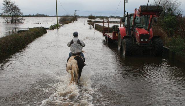
Recent flooding in Leitrim, west Cork and Kerry has brought Ireland’s flood management provisions into focus once again. eolas examines legislation and emergency measures currently in place and the forecast for how much flooding Ireland will be forced to deal with as sea levels rise.
A new study, ‘Projections of global-scale extreme sea levels and resulting episodic coastal flooding over the 21st century’, published in the Scientific Reports journal, has predicted that rising sea levels, storm surges and high tides will put an extra 23 million people under threat from coastal flooding by 2050 even with relatively ambitious and successful cuts to emissions.
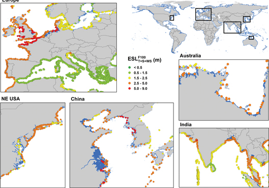
The study identifies ‘hotspot’ areas throughout the world, of which north-western Europe, including Ireland, is deemed one of the most vulnerable. The worst-case scenario outlined in the paper, where emissions are not cut and rising sea levels are not actively tackled, would put €12 trillion worth of coastal assets under threat by 2100.
In the report’s projections, extreme sea level is predicted from green (lowest) to red (highest) and Ireland’s coasts have a heavy concentration of orange, the second worst projection. This, however, is not as dire as the coasts of nearby Britain and France, which are themselves predominantly orange but dotted with red throughout, particularly France’s north coast and Britain’s south coast. Ireland’s coastal projections do not feature a single red marking.
The importance of adequate flood mitigation measures will have already been on the minds of those who populate the halls of Irish governance after the Supreme Court ruled in July that the semi-state ESB was guilty of negligence with regard to the extensive flood damage caused to buildings on the campus of University College Cork in 2009. Four of the five presiding judges found that the ESB had liability for the flood damage as the case was an exception to the principle of an individual not owing a duty of care to prevent harm to another caused by a third party. The wider implications of this ruling for the ESB’s liability coming from its management of the State’s hydroelectric dams, coupled with the threat of rising sea levels, could come to shape the State’s costs and reaction to flooding within the country.
Flood risk management falls under the auspice of the Office of Public Works (OPW), with the office responsible for the implementation of the EU Directive on the Assessment and Management of Flood Risks, which was passed into Irish law in 2010. Coastal protection and coastal flooding measures also lie with the OPW, having been transferred from the then Department of Agriculture, Fisheries and Food in 2009. The OPW’s roles in this area include: undertaking risk assessments associated with coastal flooding and erosion; provision of an advisory service for coastal flooding and erosion to support annual coastal protection funding, the Catchment-based Flood Risk Assessment and Management (CFRAM) and to inform policy development; and maintenance of the coastal protection schemes constructed under the Coastal Protection Act, 1963.
Through the CFRAM, the OPW carried out the largest ever flood risk study in Ireland, with 300 areas believed to be at risk of further flooding surveyed, and in 2019 then Minister of State with special responsibility for the Office of Public Works and Flood Relief, Kevin “Boxer” Moran published 29 Flood Risk Management Plans, which included 118 additional flood relief schemes. Since 1996, 42 flood defence schemes have been constructed throughout Ireland, protecting an estimated 9,500 properties. Eight further schemes are currently under construction, with another 26 currently in the design/development stage.
The Arterial Drainage Acts of 1945 and 1995 provide the OPW with the powers needed to improve drainage and agricultural land and undertake localised flood defence schemes to reduce threats in urban areas. The Arterial Drainage Acts and the EU Directive also introduced the OPW consent measures for the creation of mitigation measures such as watercourses, embankments, weirs, and brides.
The OPW has also prepared a Climate Change Sectoral Adaptation Plan for Flood Risk Management in line with the National adaption Framework and the Climate Action Plan. The Plan’s objectives include: enhancing understanding of the potential impacts of climate change for flooding and flood risk management; adapting flood risk management practice to effectively manage the impacts of climate change; and aligning adaptation with regards to flood risk across sectors and wider government policy.
Flooding has again struck through 2020, mainly around Ireland’s west coast, with €20,000 worth of emergency funding having been made available to businesses in Kenmare, Co. Kerry after flooding in July after heavy rainfall resulted in damages to businesses and houses and left one family in Sneem temporarily homeless. After visiting Kenmare, Minister of State for the Office of Public Works, Patrick O’Donovan TD said that he was “pleased to confirm the OPW’s commitment to progressing a €5.43 million flood relief scheme for Kenmare, for which funding has already been secured”.
Flooding has also heavily affected Co. Leitrim twice in 2020, with the River Shannon’s water levels breaching quay walls in Carrick-on-Shannon in February and the River Bonet and the Glenariff River flooding areas in north Leitrim in July. The former required the undertaking of urgent drainage work by the OPW, while the latter required an allocation of over €38,000 in emergency relief by the OPW.
“This flooding is no longer a one in 10 year event,” Leitrim County Councillor Felim Gurn stated to the Leitrim Observer in July; if predictions are accurate, they will become even more common, making the kind of investment seen in Kenmare’s relief scheme both the tip of the iceberg and the beginning of something much bigger.